


 The Climate Change/Sea Level Rise Commission consists of seven members appointed by the Commissioners of St. Michaels, with an ex-officio member from the Town Commissioners and the Planning Commission. Preference will be given to Town Residents on the Commission. Membership shall consist of representatives of the Waterways Management Advisory Board, the Chesapeake Bay Maritime Museum, waterfront business owners, and town residents, both waterfront and non-waterfront.
Ord. 523: Climate Change/Sea Level Rise Commission
The Panel meets as frequently as needed, but no less than once every three months. Unless notice is given of an alternative venue, all meetings will be held at the Boy Scout Cabin, located at 407 St. Mary’s Square.
The Commissioners have been studying Climate Change and Sea Level Rise and see the effects on St. Michaels. Chapter 14 of the St. Michaels Comprehensive Plan 2015, entitled Climate Resilience, recognizes the challenges associated with being a coastal community on the east coast with low sea-level, high water tables, and hurricane risks, and recognizes that it is crucial that the Town improve its resiliency measures.; and as such have created this commission.
Harbor and Stormwater Infrastructure Study
To read the study click HERE.
The Town of St. Michaels, MD received a Department of Natural Resources (DNR) Grant through the State of Maryland Community Resilience Program to perform an analysis of the St. Michaels harbor and stormwater infrastructure, while considering projected sea level rise over the next thirty years. The study’s objective was to develop viable, cost efficient strategies to increase the town’s resiliency relative to both rainfall and tidal induced flooding. Eight areas of study were determined, and six flooding and sea-level rise projection maps were created as part of the study scope of work. The critical study areas were evaluated within these flooding and sea-level rise scenarios to evaluate risk and define future City mitigation and adaptation efforts. Importantly, this report outlines the Next Steps our Town might take to prepare for and put plans in place to begin these mitigation efforts. The report was prepared by George, Miles & Buhr, LLC.
St. Michaels Awarded 2 Grants – Climate Change/Sea Level Rise Commission Encouraging Community Participation
The Town of St. Michaels was recently awarded two Maryland Department of Natural Resources grants. The Town Commissioners and Climate Change/Sea Level Rise Commission (CC/SLRC) will now move forward to implement the grants.
The first grant, “Resiliency Through Restoration: St. Michaels West Harbor Road/East Chew Avenue Flood Mitigation Feasibility Assessment and Conceptual Design” is a study which will develop proposed mitigation strategies for the projected stormwater flooding and sea level rise in this area by 2050. The study will include a conceptual design considering the West Harbor Road and East Chew Avenue roadways, adjacent residences, hotel, Town boat slips, boat ramps and associated parking.
The second grant, “St. Michaels San Domingo Creek and Westside Stormwater and Harbor Infrastructure Assessment and Flood Mitigation Study” is to complete a tidal, sea level rise, and stormwater assessment which identifies at risk infrastructure, community assets, and properties on the San Domingo watershed side of our Town and develop proposed mitigation strategies.
Each of these grants will have a formal kickoff in early 2023, with drafts and final reports by the end of the year. The CC/SLRC wishes to encourage Town participation, so residents are aware of project meetings and have an opportunity to provide input and to comment on proposed strategies and concept designs.
As such, the CC/SLRC would like to develop a contact list of residents and businesses who would like to be kept aware of meetings and project status. If you would like to be contacted for one or both projects, please send your contact information to Kris Kakabar at info@stmichaelsmd.gov.
We are looking forward to your support and input as we jointly plan our Town of St. Michaels Future.
Thank you,
Members of the Climate Change/Sea Level Rise Commission
Climate Change/Sea Level Rise Commission BayLand Presentation at Community Input Session on March 16, 2023
 Anna Johnson, Project Engineer with BayLand Consultants & Designers, Inc., held a community input session with a power point presentation on “San Domingo Creek and West Side Stormwater and Harbor Infrastructure Assessment and Flood Mitigation Study”. This informative presentation can be found HERE. BayLand is interested in your feedback regarding flooding concerns, areas of peak interest, and any mitigation solutions you would like to see implemented. Please visit this link, complete the attached form and return it to Anna Johnson, PE at ajohnson@baylandinc.com.
San Domingo Creek and Westside Stormwater and Flood Mitigation Study – Vulnerability Assessment Presentation on May 11, 2023
The Town received a briefing on the San Domingo Creek and Westside Stormwater and Flood Mitigation Study from BayLand consultant and Project Engineer, Anna Johnson. She reviewed with the CC/SLRC and public their vulnerability assessment for the at-risk flooding areas on the San Domingo Creek side of St. Michaels. Ms. Johnson will use this information and feedback to move forward with this project and plan to meet again with the Town and public on August 10, 2023 at the 5:00pm meeting.
San Domingo Creek and Westside Stormwater and Flood Mitigation Study – Mitigation Strategies Discussion on August 10, 2023
Anna Johnson, BayLand consultant and Project Engineer, presented BayLand’s draft mitigation strategies for the San Domingo Creek side of St. Michaels at risk flooding areas to the CC/SLRC and the Town residents. The CC/SLRC will use this updated information to make decisions toward designating which of BayLand’s Conceptual Design will be carried out to 30% Construction Design Plans. We have attached Ms. Johnson’s Progress draft of this project. Please note that this is a DRAFT and will continue to be modified as the project progresses to completion. Click here for the Progress DRAFT of the St. Michaels San Domingo Creek and West Side Stormwater and Harbor Infrastructure Assessment and Flood Mitigation Study. For more detailed explanation of this Progress Draft, please view the meeting attached here.
San Domingo Creek and Westside Stormwater and Flood Mitigation Study – Draft Report and 30% Design Options Reviewed on November 9, 2023
BayLand’s Anna Johnson, presented their latest draft report and two option designs for the proposed Back Creek Park living shoreline on the San Domingo Creek side of St. Michaels to the CC/SLRC. They have chose option two to carry forward to 30% Construction Design Plans. Please note that this is a DRAFT and will continue to be modified as the project progresses to completion. Click here for the DRAFT REPORT and TWO DESIGN OPTIONS of the St. Michaels San Domingo Creek and West Side Stormwater and Harbor Infrastructure Assessment and Flood Mitigation Study. For more detailed explanation of this draft, please view the meeting attached here.
San Domingo Creek and Westside Stormwater and Flood Mitigation Study – Final Draft Report and 30% Design Option Presented to the Commissioners on December 13, 2023
BayLand’s coastal engineer and project manager, Anna Johnson, presented their final draft report and 30% design option proposed for Back Creek Park living shoreline on the San Domingo Creek side of St. Michaels to the Commissioners of St. Michaels, CC/SLRC, and our community. Click here for the FINAL DRAFT POWERPOINT PRESENTATION, FINAL REPORT, and 30% DESIGN OPTION. For a more detailed explanation of this presentation, please view the COSM meeting attached here.
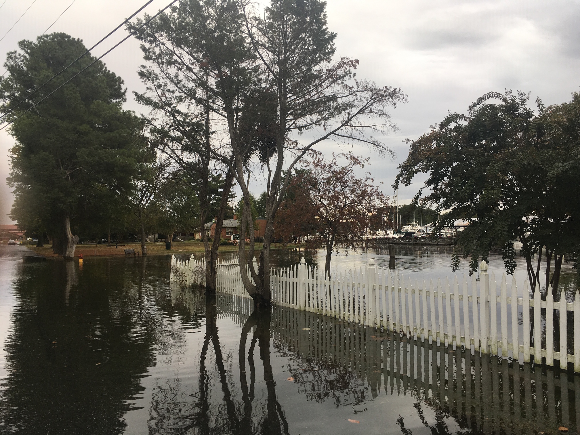
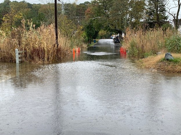
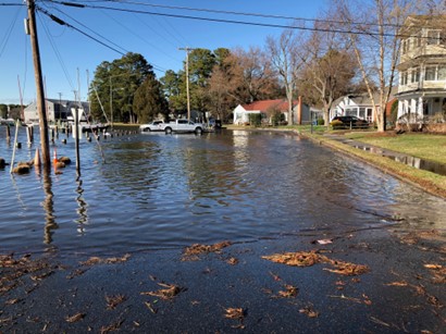
St. Michaels Floodwatch
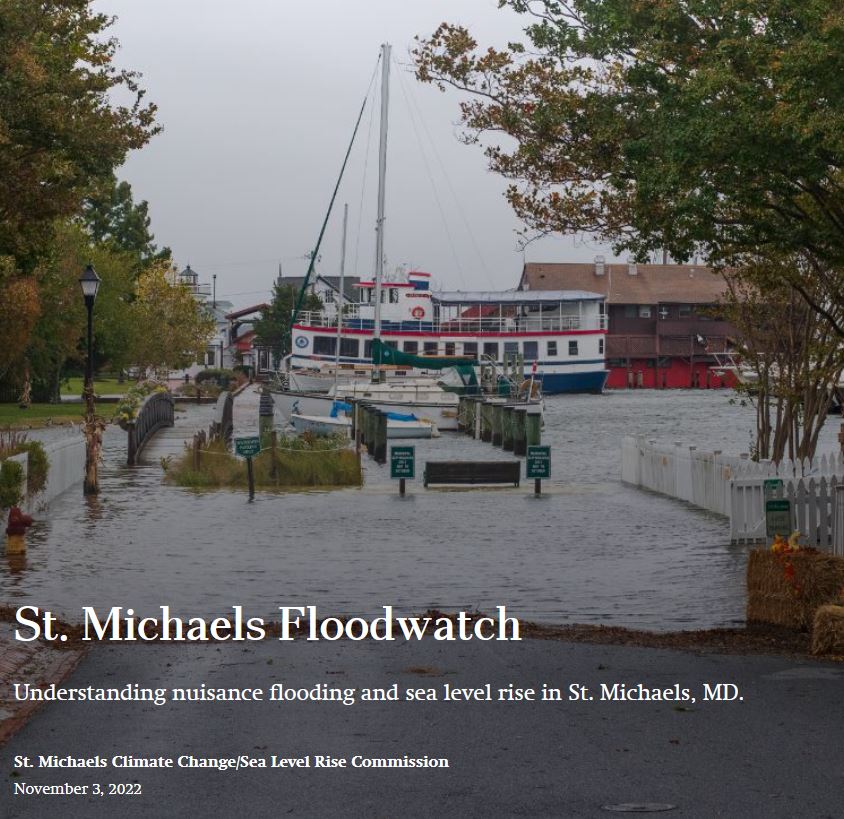 The Climate/Change/Sea Level Rise Commission is pleased to present St. Michaels Floodwatch, an interactive tool to help residents and visitors to our town understand the effect that sea level rise and nuisance flooding will have over the next 30 years. On the Floodwatch site, you can view projections of what chronic nuisance flooding is projected to look like by 2050, overlaid on satellite images of the town and throughout Talbot County. You can also view photographs of recent flooding events in critical areas around town.
St. Michaels Floodwatch: http://stmichaelsfloodwatch.com/
Residents are also invited to submit their own images of local flooding through the Maryland MyCoast app, which can be accessed here: https://mycoast.org/md
Andrew Thaler, from the Climate Change/Sea Level Rise Commission, and Kate Vogel, from Maryland DNR, will present both the Floodwatch project and MyCoast app during a Lunch and Learn session at the St. Michaels Library at 11a.m. on January 19, 2023.
GMB Community Input Session Open House for West Harbor Road/East Chew Avenue Sea Level Rise and Stormwater Flooding Conceptual Design on March 30, 2023
 Brent Jett, P.E., CFM, CC-P, Sr. Project Manager/Coastal Resiliency Group Leader (and author of the initial Harbor and Stormwater Infrastructure Study) along with other Architects/Engineers with George, Miles & Buhr, LLC (GMB), held an open house on “Resiliency Through Restoration: West Harbor Road/East Chew Avenue Flood Mitigation Feasibility Assessment and Conceptual Design” to allow the community to ask questions and provide crucial community input, while taking time to better understand this study. An aerial view depicting the area of interest for this study may be viewed HERE. GMB is interested in your feedback regarding flooding concerns, areas of peak interest, and any mitigation solutions you would like to see implemented. Please visit this link, complete the attached survey and return it to Brent Jett, PE at bjett@gmbnet.com.
GMB Community Input/Feedback Session for West Harbor Road/East Chew Avenue Flood Mitigation Study was held on July 13, 2023
GMB developed two design concepts for the West Harbor Road/East Chew Avenue area which they shared with the community and received their feedback toward moving forward with this project. Below we have attached several documents related to this project for your review. Please join us at our next meeting on August 15th when GMB will share the findings of their stormwater evaluation and more discussions will be held regarding proposed options.
Brent Jett’s Power Point Presentation
West Harbor Boat Slip Parking Memo by Mr. Glackin
West Harbor Parking Survey Results by Mr. Glackin
July 13, 2023 CC/SLRC Minutes Summary by Mr. Glackin
GMB Presentation for West Harbor Road/East Chew Avenue Flood Mitigation Study to the Commissioners of St. Michaels, CC/SLRC, and Community at the COSM Working and Legislative Session held on December 5, 2023
GMB presented their Resiliency Through Restoration: West Harbor Road/East Chew Avenue Flood Mitigation Feasibility Assessment and Conceptual Design to the Commissioners for their approval. Click here for the FINAL REPORT.
Brent Jett’s Power Point Presentation
Advanced Assistance Grant Flood Mitigation Study from FEMA, administered by MDEM, Town of St. Michaels, MD – Cherry Street/Honeymoon Bridge-Harbor Walkway Presentation on January 26, 2024
The Town of St. Michaels and the Climate Change/Sea Level Rise Commission (CC/SLRC) have received an Advanced Assistance grant form the Federal Emergency Management Agency (FEMA), administered by the Maryland Department of Emergency Management (MDEM), to address the sea level rise and stormwater flooding projected in our Town’s future. The first phase of this study is to develop an overall concept plan for the Cherry St./Honeymoon Bridge-Harbor Walkway, Burns St., and Mill St. Area. The Town has hired Rauch Inc. to assist in completing this study. Their study will develop an overall concept plan for this area in the first half of this year. Then building on this concept plan, Rauch will complete the detailed design and construction drawings in the second half of the year.
On January 25th, 2024, Rauch Inc. and Annapolis Landscape Architects made an initial presentation to brief the residents of Cherry Street/Honeymoon Bridge-Harbor Walkway on the study, receive their input and allow them to participate from inception of this project. Please view the meeting presentation by clicking HERE.
On January 31st, 2024, Rauch Inc. and Annapolis Landscape Architects met with the Chesapeake Bay Maritime Museum to provide them with an initial presentation and obtain their input from inception of this project. Please view the meeting presentation by clicking HERE.
St. Michaels Awarded Harbor Flooding & Stormwater Mitigation Project Grant
The Town of St. Michaels has been awarded another large grant to tackle the threat of Rising Sea Level and Stormwater Flooding. Working with the Maryland Department of Emergency Management, the Climate Change/Sea Level Rise Commission has secured this $210,000 federal grant. The Federal Emergency Management Agency recently approved the grant money for the St. Michaels Harbor Flooding & Stormwater Mitigation Project.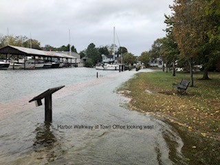
This Project is to develop a concept plan and gather Benefit Cost Analysis (BCA) information to address flooding concerns at Cherry St./Honeymoon Bridge – Harbor Walkway, Mill St., Burns St., Muskrat Park/Church St., and Mulberry St. This grant will complete the development of Concept Designs for the critical flooding areas of our main harbor identified in our initial Harbor and Stormwater Infrastructure Study.
The CC/SLRC is preparing for the Kickoff meeting for this grant and is looking forward to beginning implementation of this grant in the second half of this year. This project will be done in two phases spread out over the next three years. The first phase will focus on the Cherry St./Honeymoon Bridge-Walkway, Mill St., and Burns St. area. The second phase will focus on Muskrat Park/Church St. and on Mulberry St. areas.
The CC/SLRC are looking forward to working with our St. Michaels Community as this project proceeds and the concept plans are developed.
July 25, 2023, Press Release: Secretary Strickland Visits St. Michaels; Tours flood-prone areas (click to read more)
| Members | Term Ending |
| Roy B. Myers, Chair | 12/31/2025 |
| Dennis F. Glackin, Vice-Chair | 12/31/2024 |
| John Marrah | 12/31/2025 |
| Douglas Rollow | 12/31/2024 |
| William Boicourt | 12/31/2027 |
| Donald McCann | 12/31/2027 |
| Andrew Thaler | 12/31/2026 |
| Vacancy, Ex-Officio/Planning Commission | 12/31/2027 |
| Vacancy, Ex-Officio/COSM | 12/31/2027 |
DRAFT Upcoming Agendas
None at this time
The following are minutes from previous meetings of the commission:
4-11-24 Video; 4-11-24 Audio;
3-14-24 Video; 3-14-24 Audio; 3-14-24 Minutes
2-8-24 Video; 2-8-24 Audio; 2-8-24 Minutes
1-9-24 Video; 1-9-24 Audio; 1-9-24 Minutes
12-14-23 Video; 12-14-23 Audio; 12-14-23 Minutes
11-9-23 Video; 11-9-23 Audio; BayLand draft report; BayLand Design Options; 11-9-23 Minutes
10-12-23 Video; 10-12-23 Audio; 10-12-23 Minutes
9-14-23 Video; 9-14-23 Audio; 9-14-23 Minutes
8-24-23 Video; 8-24-23 Audio; 8-24-23 Minutes
8-10-23 Video; 8-10-23 Audio; 8-10-23 Minutes
7-13-23 Video; 7-13-23 Audio; 7-13-23 Minutes
6-8-23 Video; 6-8-23 Audio; 6-8-23 Minutes
5-11-23 Video; 5-11-23 Audio; 5-11-23 Minutes
4-13-23 Video; 4-13-23 Audio; 4-13-23 Minutes
3-16-23 Video; 3-16-23 Audio; 3-16-23 Power Point Presentation; 3-16-23 Community Input Questionnaire; 3-16-23 Minutes
3-9-23 Video; 3-9-23 Audio; 3-9-23 Minutes
2-9-23 Video; 2-9-23 Audio; 2-9-23 Minutes
1-19-23 Video; 1-19-23 Audio; 1-19-23 Minutes
1-12-23 Video; 1-12-23 Audio; 1-12-23 Minutes
12-8-22 Video; 12-8-22 Audio; 12-8-22 Minutes
12-6-22 Video; 12-6-22 Audio; 12-6-22 Minutes
11-10-22 Video; 11-10-22 Audio; 11-10-22 Minutes
10-13-22 Video; 10-13-22 Audio; 10-13-22 Minutes
8-11-22 Video; 8-11-22 Audio; 8-11-22 Minutes
7-14-22 Video; 7-14-22 Audio;
6-9-22 Video; 6-9-22 Audio; 6-9-22 Minutes
5-12-22 Video; 5-12-22 Audio; 5-12-22 Minutes
4-14-22 Video; 4-14-22 Audio; 4-14-22 Minutes
3-10-22 Video; 3-10-22 Audio; 3-10-22 Minutes
2-10-22 Video; 2-10-22 Audio; 2-10-22 Minutes
1-13-22 Video; 1-13-22 Audio; 1-13-22 Minutes
12-9-21 Video; 12-9-21 Audio; 12-9-21 Minutes
11-16-21 Video; 11-16-21 Audio; 11-16-21 Minutes
10-14-21 Video; 10-14-21 Audio; 10-14-21 Minutes
9-9-21 Video; 9-9-21 Audio; 9-9-21 Minutes
8-12-21 Video; 8-12-21 Audio; 8-12-21 Minutes
7-8-21 Video; 7-8-21 Audio; 7-8-21 Minutes
6-15-21 Video; 6-15-21 Audio; 6-15-21 Minutes
Miscellaneous Work Products:
Town/Police Department Crosby Sketch Plan, 2023
Cherry St. Flood Mitigation Sketch, 2022