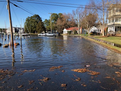
 The Town of St. Michaels is moving forward with proactive measures to mitigate rising tides. The Commissioners of St. Michaels have recently approved a set of ambitious recommendations from the newly empaneled Climate Change/Sea Level Rise Commission. The CC/SLR Commission has identified priority projects based on long range predictions outlined in a report from GMB Engineers/Architects. The study predicts increasing tide levels over the next 30 years that will cause serious flooding along the Town’s waterfronts.
CC/SLR Chairman Roy Myers presented the aggressive project schedule to the Town Commissioners on August 25th. The Commissioners have approved the plan and will be working with the CC/SLR Commission to secure the necessary funding and grants to move the plan forward. Engineering studies will be underway over the next year and will be followed by the following specific projects:
2023 to 2025 Projected Timeframe
• Construction of E. Chew/W. Harbor Road Improvements
• Begin Phased construction of Honeymoon Bridge, Harbor walkways, Burns, Mill and
Cherry Streets Master Plan.
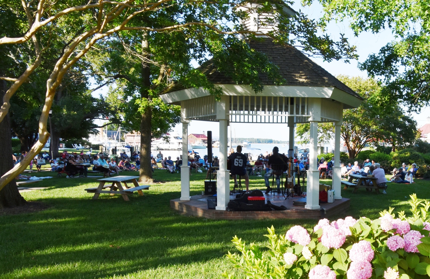
• Grant and Engineering Design completed for Muskrat Park and Church Street area.
• In conjunction with adjacent properties, complete strategies/plans for Mulberry Street,
Westside Harbor residents, Carpenter Street and San Domingo Town residents.
2025 to 2030 Projected Timeframe
• Complete Construction of Muskrat Park Improvements
• Complete Engineering Studies for Mulberry Street and Carpenter Street
• Complete construction of Master Plan – Construction for Honeymoon Bridge, Harbor
walkways, Burns, Mill and Cherry Streets
• Complete Engineering Plans for San Domingo/Back Creek harbor side of St. Michaels.
• Assist Westside Harbor residents in their plans as appropriate.
FOR MORE INFORMATION AND A COPY OF THE GMB STUDY, CONTACT THE TOWN ADMINISTRATOR ROB STRAEBEL AT: rstraebel@stmichaelsmd.gov or more information HERE.
Advanced Assistance Grant Flood Mitigation Study from FEMA, administered by MDEM, Town of St. Michaels, MD – Cherry Street/Honeymoon Bridge-Harbor Walkway Presentation on January 26, 2024
The Town of St. Michaels and the Climate Change/Sea Level Rise Commission (CC/SLRC) have received an Advanced Assistance grant form the Federal Emergency Management Agency (FEMA), administered by the Maryland Department of Emergency Management (MDEM), to address the sea level rise and stormwater flooding projected in our Town’s future. The first phase of this study is to develop an overall concept plan for the Cherry St./Honeymoon Bridge-Harbor Walkway, Burns St., and Mill St. Area. The Town has hired Rauch Inc. to assist in completing this study. Their study will develop an overall concept plan for this area in the first half of this year. Then building on this concept plan, Rauch will complete the detailed design and construction drawings in the second half of the year.
On January 25th, 2024, Rauch Inc. and Annapolis Landscape Architects made an initial presentation to brief the residents of Cherry Street/Honeymoon Bridge-Harbor Walkway on the study, receive their input and allow them to participate from inception of this project. Please view the meeting presentation by clicking HERE.
On January 31st, 2024, Rauch Inc. and Annapolis Landscape Architects met with the Chesapeake Bay Maritime Museum to provide them with an initial presentation and obtain their input from inception of this project. Please view the meeting presentation by clicking HERE.
Climate Change/Sea Level Rise Commission BayLand Presentation at Community Input Session on March 16, 2023
Anna Johnson, Project Engineer with BayLand Consultants & Designers, Inc., held a community input session with a power point presentation on “San Domingo Creek and West Side Stormwater and Harbor Infrastructure Assessment and Flood Mitigation Study”. This informative presentation can be found HERE. BayLand is interested in your feedback regarding flooding concerns, areas of peak interest, and any mitigation solutions you would like to see implemented. Please visit this link, complete the attached form and return it to Anna Johnson, PE at ajohnson@baylandinc.com.
San Domingo Creek and Westside Stormwater and Flood Mitigation Study – Vulnerability Assessment Presentation on May 11, 2023
The Town received a briefing on the San Domingo Creek and Westside Stormwater and Flood Mitigation Study from BayLand consultant and Project Engineer, Anna Johnson. She reviewed with the CC/SLRC and public their vulnerability assessment for the at-risk flooding areas on the San Domingo Creek side of St. Michaels. Ms. Johnson will use this information and feedback to move forward with this project and plan to meet again with the Town and public on August 10, 2023 at the 5:00pm meeting.
San Domingo Creek and Westside Stormwater and Flood Mitigation Study – Mitigation Strategies Discussion on August 10, 2023
Anna Johnson, BayLand consultant and Project Engineer, presented BayLand’s draft mitigation strategies for the San Domingo Creek side of St. Michaels at risk flooding areas to the CC/SLRC and the Town residents. The CC/SLRC will use this updated information to make decisions toward designating which of BayLand’s Conceptual Design will be carried out to 30% Construction Design Plans. We have attached Ms. Johnson’s Progress draft of this project. Please note that this is a DRAFT and will continue to be modified as the project progresses to completion. Click here for the Progress DRAFT of the St. Michaels San Domingo Creek and West Side Stormwater and Harbor Infrastructure Assessment and Flood Mitigation Study. For more detailed explanation of this Progress Draft, please view the meeting attached here.
San Domingo Creek and Westside Stormwater and Flood Mitigation Study – Draft Report and 30% Design Options Reviewed on November 9, 2023
BayLand’s Anna Johnson, presented their latest draft report and two option designs for the proposed Back Creek Park living shoreline on the San Domingo Creek side of St. Michaels to the CC/SLRC. They have chose option two to carry forward to 30% Construction Design Plans. Please note that this is a DRAFT and will continue to be modified as the project progresses to completion. Click here for the DRAFT REPORT and TWO DESIGN OPTIONS of the St. Michaels San Domingo Creek and West Side Stormwater and Harbor Infrastructure Assessment and Flood Mitigation Study. For more detailed explanation of this draft, please view the meeting attached here.
San Domingo Creek and Westside Stormwater and Flood Mitigation Study – Final Draft Report and 30% Design Option Presented to the Commissioners on December 13, 2023
BayLand’s coastal engineer and project manager, Anna Johnson, presented their final draft report and 30% design option proposed for Back Creek Park living shoreline on the San Domingo Creek side of St. Michaels to the Commissioners of St. Michaels, CC/SLRC, and our community. Click here for the FINAL DRAFT POWERPOINT PRESENTATION, FINAL REPORT, and 30% DESIGN OPTION. For a more detailed explanation of this presentation, please view the COSM meeting attached here.
GMB Community Input Session Open House for West Harbor Road/East Chew Avenue Sea Level Rise and Stormwater Flooding Conceptual Design on March 30, 2023
Brent Jett, P.E., CFM, CC-P, Sr. Project Manager/Coastal Resiliency Group Leader (and author of the initial Harbor and Stormwater Infrastructure Study) along with other Architects/Engineers with George, Miles & Buhr, LLC (GMB), held an open house on “Resiliency Through Restoration: West Harbor Road/East Chew Avenue Flood Mitigation Feasibility Assessment and Conceptual Design” to allow the community to ask questions and provide crucial community input, while taking time to better understand this study. An aerial view depicting the area of interest for this study may be viewed HERE. GMB is interested in your feedback regarding flooding concerns, areas of peak interest, and any mitigation solutions you would like to see implemented. Please visit this link, complete the attached survey and return it to Brent Jett, PE at bjett@gmbnet.com.
GMB Community Input/Feedback Session for West Harbor Road/East Chew Avenue Flood Mitigation Study was held on July 13, 2023
GMB developed two design concepts for the West Harbor Road/East Chew Avenue area which they shared with the community and received their feedback toward moving forward with this project. Below we have attached several documents related to this project for your review. Please join us at our next meeting on August 15th when GMB will share the findings of their stormwater evaluation and more discussions will be held regarding proposed options.
Brent Jett’s Power Point Presentation
West Harbor Boat Slip Parking Memo by Mr. Glackin
West Harbor Parking Survey Results by Mr. Glackin
July 13, 2023 CC/SLRC Minutes Summary by Mr. Glackin
GMB Presentation for West Harbor Road/East Chew Avenue Flood Mitigation Study to the Commissioners of St. Michaels, CC/SLRC, and Community at the COSM Working and Legislative Session held on December 5, 2023
GMB presented their Resiliency Through Restoration: West Harbor Road/East Chew Avenue Flood Mitigation Feasibility Assessment and Conceptual Design to the Commissioners for their approval. Click here for the FINAL REPORT.
Brent Jett’s Power Point Presentation
St. Michaels Preparing for Nuisance Flooding
Andrew Thaler, from the Climate Change/Sea Level Rise Commission and developer of the St. Michaels Floodwatch, and Kate Vogel, from Maryland DNR and MyCoast web application, have presented both the Floodwatch project and MyCoast app during Lunch and Learn sessions at both the Talbot County Library St. Michaels and Easton branches. More recently, they were interviewed by WBOC’s Lauren Miller to explain how their interactive technology is helping to prepare and educate our communities about nuisance flooding along the Eastern Shore. Please take a moment to watch this interview by clicking on the attached link HERE.
St. Michaels Awarded Flooding & Stormwater Mitigation Project Grant
The Town of St. Michaels has been awarded another large grant to tackle the threat of rising sea levels. Working with the Maryland Department of Emergency Management, the Town has secured a $210,000 federal grant. The Federal Emergency Management Agency has approved this grant money for the Town’s Harbor Flooding and Stormwater Mitigation Project.
This federal grant follows two state grants amounting to $115,000. These grants from the Department of Natural Resources are currently funding concept designs for two flood-prone areas.
The grants are the results of efforts by the Town’s Climate Change/Sea Level Rise Commission which was empaneled in the summer of 2021. Commission Chair Roy Myers says, “This latest grant builds upon our current efforts to complete the concept designs for flooding mitigation in our main harbor areas. We are grateful to MDEM and FEMA for their support and are looking forward to working with them on the implementation of this grant.”
St. Michaels Commissioners President David Breimhurst says, “This is terrific news for St. Michaels and for Talbot County. St. Michaels is home to the County’s second largest employer and is the primary source of the County’s multi-million-dollar tourism industry. Protecting our Town from the threat of sea level rise is our top priority. We congratulate and thank Mr. Myers and his commission for the many hours of hard work that have paid off with these significant grants.” The CC/SLR Commission’s work has become a vital element of the town’s long range plans and will help shape the Town’s 2025 Comprehensive Plan. The Commission has been reaching out to the public for guidance and is providing updated information. Recently, the state Department of Natural Resources partnered with the CC/SLRC, linking its online MYCOAST tool with the St Michaels Floodwatch website. The Floodwatch interactive tool was created by Commission member Andrew Thaler and can be found online at http://stmichaelsfloodwatch.com. There is also a link on the town website, stmichaelsmd.gov Residents can use the tool to understand how their Talbot County properties might be affected by sea level rise projections. Roy Myers says, “It is a graphic view of why the town needs to plan today for tomorrow’s sea level rise and stormwater flooding.”
July 25, 2023, Press Release: Secretary Strickland Visits St. Michaels; Tours flood-prone areas (click to read more)


